In San Bernardino, much of our work starts with the same observation: water behaves differently on these mountain fronts than anywhere else in Southern California. The alluvial fans that spread out from the San Bernardino Mountains create a mix of cobbles, sands, and silty clays that shift unpredictably under heavy rain. Roads here don't just fail from traffic loads — they fail because subsurface drainage gets blocked by fine particles migrating into the coarser layers. That's why geotechnical road drainage in San Bernardino has to account for both surface runoff and deep groundwater seepage. We've seen too many pavement failures where a standard culvert was installed without a proper filter design, only to have it clog within two seasons. Before we recommend any drainage system, we always run a full permeability field test to measure how fast water actually moves through the native soil at depth, not just at the surface.
Water behaves differently on these mountain fronts — roads fail when subsurface drainage gets blocked by fine particles migrating into coarser layers.
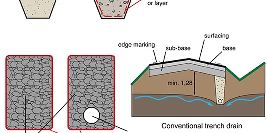
Approach and scope
A common mistake we see among contractors new to San Bernardino is assuming that highway drainage design from the coast will work here. It won't. The soils along the I-215 corridor and up into the foothills have high fines content — sometimes over 40 percent passing the No. 200 sieve — which means they hold water and become plastic when saturated. Effective geotechnical road drainage in San Bernardino requires a subsurface drainage blanket with properly graded filter layers, not just a perforated pipe wrapped in geotextile. The fines can still clog the fabric if the design doesn't account for the local soil gradation. In our projects, we pair this with a consolidation test to predict how much the subgrade will settle when water is finally allowed to drain out. Without that data, you might design a drainage system that works for the first year but fails as the soil consolidates and changes its hydraulic conductivity.
Technical reference image — San Bernardino
Site-specific factors
Compare two neighborhoods in San Bernardino — the alluvial fans near Lytle Creek versus the older terrace deposits around Arrowhead Springs. In the Lytle Creek area, coarse sands and gravels drain quickly but can scour out beneath roads during flash floods. Arrowhead Springs, by contrast, has dense clay layers that hold water for weeks after a storm, causing the road base to soften and rut. Geotechnical road drainage in San Bernardino has to be tailored to which geologic unit you're building on. If you install a standard edge drain system on those clays without a wicking layer, you'll see pavement failure within two to three wet seasons. We've documented cases where shoulder cracking appeared after just one winter because the drainage system wasn't designed for the local plasticity index.
We design drainage blankets, edge drains, and trench drains using soil-specific gradation curves and permeability data. Our team selects filter materials that prevent piping and clogging, validated by laboratory sieve analysis and hydraulic conductivity tests. For San Bernardino projects, we also model seasonal groundwater fluctuations using local well records.
We perform field borehole permeameter tests and double-ring infiltrometer tests to measure in-situ drainage rates. Combined with CBR and resilient modulus testing, we determine whether the native subgrade can support pavement loads after saturation. This service is critical for roads in the alluvial fan zones where granular layers can be highly variable.
How does geotechnical road drainage differ from standard stormwater drainage?
Standard stormwater drainage handles surface runoff via gutters and pipes, while geotechnical road drainage focuses on removing water from within the pavement structure and subgrade. In San Bernardino's clay-rich soils, subsurface drainage prevents pore pressure buildup that can reduce bearing capacity. Without it, even a well-paved road can fail from below during prolonged wet periods.
What is the typical cost range for a geotechnical road drainage study in San Bernardino?
For a standard road segment or subdivision project, costs typically range between US$900 and US$2,650. This covers field infiltration testing, laboratory permeability analysis, and a design report with filter layer recommendations. Larger highway projects with multiple test locations may exceed this range.
Which Caltrans standards apply to road drainage design in San Bernardino County?
The Caltrans Highway Design Manual Chapter 860 governs subsurface drainage design. For pavement subgrade evaluation, we follow Caltrans' Standard Specifications Section 68 for permeable materials. Projects near the San Bernardino National Forest also require coordination with the Regional Water Quality Control Board for stormwater discharge compliance.
How do alluvial fan soils affect drainage system longevity?
Alluvial fan deposits in San Bernardino are heterogeneous — cobbles and sands mixed with lenses of silt and clay. Water can flow quickly through the coarse layers but get trapped above the fine layers. Over time, fines migrate into the drainage aggregate, clogging it. Our designs incorporate graded filter layers with controlled pore sizes to prevent this migration, extending the drainage system's life to 20+ years.